Africa
It’s Time to Show Africa’s True Size on the Map

It’s Time to Show Africa’s True Size on the Map
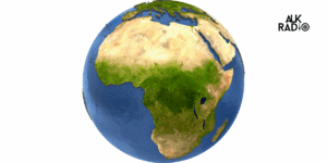
For centuries, the world map has been a tool of navigation, education, and geopolitics. Yet the most widely used version — the Mercator projection — has misrepresented reality, especially when it comes to Africa. In classrooms, newsrooms, and digital platforms, Africa often appears smaller than Europe or North America, despite being larger than both combined.
Today, a growing movement of campaigners, educators, and African institutions is calling for change. Their demand is simple: redraw the map to reflect Africa’s true scale.
The Mercator map, designed in the 16th century for European sailors, exaggerated the size of countries near the poles (like Greenland and Russia) while shrinking those near the equator — Africa most of all.
- On most Mercator maps, Greenland looks larger than Africa. In reality, Africa is about 14 times bigger.
- Europe appears almost the same size as Africa, but the truth is that Africa can fit the U.S., China, India, Japan, and most of Europe combined within its borders.
This distortion is not just a geographical error — it has shaped perceptions of power, importance, and global influence.
To correct these distortions, campaigners are championing alternatives such as the Equal Earth projection, which presents continents in their true proportions. The African Union has even voiced support for teaching maps that reflect reality, ensuring young people grow up with a correct understanding of their continent’s scale and significance.
By correcting the map, advocates argue, we correct history — and challenge a narrative that has long downplayed Africa’s size and potential.
Why It Matters ?
Representation is never trivial. Maps shape how we see the world — and ourselves. When Africa is consistently shown as smaller, it reinforces outdated colonial mindsets of marginalization. Recognizing its true size highlights Africa’s immense resources, cultural diversity, and growing geopolitical importance in a rapidly changing global order.
As South Africa leads a G20 taskforce on global inequality and African nations push for greater influence in international institutions, the symbolic power of an accurate map resonates more than ever.
Changing the map in classrooms, media, and digital platforms is a small but powerful step toward rebalancing global narratives.
For AUKMedia, it is also a reminder of the role media plays in shaping perspectives.
Africa is not just big — it is vast, dynamic, and central to the future of our planet. The map should finally reflect that truth.